


lac de l'ascension

orsel
User GUIDE

Length
14.2 km

Max alt
2448 m

Uphill gradient
831 m
Km-Effort
25 km

Min alt
1781 m

Downhill gradient
832 m
Boucle
No
Creation date :
2022-08-08 06:58:03.167
Updated on :
2022-08-08 15:34:18.298
6h18
Difficulty : Medium

FREE GPS app for hiking
 SityTrail
IGN / Geographical institutes
SityTrail Plus
The world is yours!
About
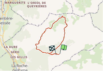
Trail Walking of 14.2 km to be discovered at Provence-Alpes-Côte d'Azur, Hautes-Alpes, La Roche-de-Rame. This trail is proposed by orsel.
Description
le 8 août
Positioning
Country:
France
Region :
Provence-Alpes-Côte d'Azur
Department/Province :
Hautes-Alpes
Municipality :
La Roche-de-Rame
Location:
Unknown
Start:(Dec)
Start:(UTM)
312317 ; 4959146 (32T) N.
Comments